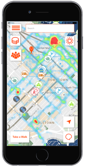
The Go Downtown app helps users find out what is happening in town right now.
Go Downtown has launched a public pilot of its real-time urban mapping mobile application in the Metro Vancouver area. The app is now free to download at the Canadian App Store and Google Play.
The new app helps users in large cities find out what is happening around town right now, and where to go to participate. The app indicates the location of live events and highlights crowd hot spots using a live foot-traffic heatmap.
The main mapping platforms like Google, Apple or Bing present mostly static data, while the information about live urban events – such as bands, parties, shows, etc. – is fragmented across the net and hard to find. Go Downtown changes the way we plan our hangouts and find out where the action is, by visualizing the live city. The social app aggregates information about events – such as festivals, shows, live music, food truck locations, happy hours and more – from user reports and other sources and displays them on the map. Users can share the details of an event they like and the app produces a walking route to take them there.
 Go Downtown also features a live foot-traffic heatmap. The app aggregates the location and speed of its users to generate a real-time foot-traffic “synoptic map.” The heatmap highlights pedestrian hot spots and helps users find where the action is and where people are going. Users can even filter the map to find hot spots of specific groups of people based on their demographic and common interests.
In addition, the app offers themed walking routes – like “tourist attractions,” “shopping spree,” “pub crawl” and other things near the user – that enable the user to explore the city by walking.
“The concept of real-time urban mapping is powerful,” said Yaron Bazaz, co-founder and chief executive officer of Go Downtown. “Waze revolutionized mapping by using real-time user reports to map current traffic congestions and help drivers. Go Downtown takes real-time mapping further by utilizing user inputs to depict urban life. Where are people hanging out right now, what cultural events are taking place today? The ability to digest all this information, visualize it and analyze patterns will have enormous impact on users, businesses and local authorities.”
In addition, the real-time foot-traffic data and live urban events information generated serves a wide range of markets: from leading retail chains and car-sharing ventures that would like to understand foot-traffic patterns, to universities and cities that can use it for better planning. Go Downtown predicts that live foot-traffic data pattern analysis and forecast will play a key role in many Smart City initiatives and will be widely used by urban planners to plan more pedestrian-friendly cities.
Earlier this year, the startup ran a successful pilot at the University of British Columbia with the support of the faculty and the student organization. During the pilot, the app aggregated the foot traffic of hundreds of participants and mapped the main walking routes students were using throughout the campus.
Following the public pilot in Vancouver, the company plans to expand the service to more cities in Canada and the United States. To participate in the Vancouver pilot, visit godowntown.mobi to download the iOS version from the App Store or the Android version from Google Play.


 Mitzvah Tools 2.0, which was released in June, was developed with the help of Cantor Mark Britowich, director of sales and operations at Mitzvah Tools, who has more than 20 years of experience in b’nai mitzvah education. Vancouver’s Mark Fromson was the project manager and Australia-based Salim Jordan led an international team of programmers.

